在New Hampshire的白山有一片總統山脈,由13個山峰組成,9座山海拔超過4000英尺,其中7座山峰命名為總統的名字:Mount Washington, Mount Adams, Mount,Jefferson,Mount Madison, Mount Monroe, Mount Franklin, Mount Eisenhower。
上個月Memorial Day長周末和LP到白山爬山。5月28日開車到達白山已經過了中午,決定到華盛頓山去。1784年Reverend Jeremy Belknap首先記錄了華盛頓山峰。華盛頓山海拔6228英尺(1917米),是密西西比河以東最高的山峰。以風大,氣候惡劣多變著名。不到山頂上很難想象狂風像脫韁的野馬,冰雨刺骨撕心裂肺之寒冷。
山頂一個Mt. Washington Obsevatory Wheather Discovery Center,裏麵有一個餐廳,觀察站的老儀器展廳,博物館和禮品店,還有寄明信片的小店
人們都跑進去避雨
山上動物標本
觀測儀器
狂風極其狂烈,夾著冰雨,還有冰粒打得臉生疼,3米就看不見了
拚死也得到山頂處,根本無法站得穩,眼睛也睜不開,冷的瑟瑟發抖
終於到了山頂,可是視野隻有3米,什麽也看不見。
晴天可以看到波士頓,介紹說甚至可以看到紐約。
隻能下山了
這輛車正準備上山
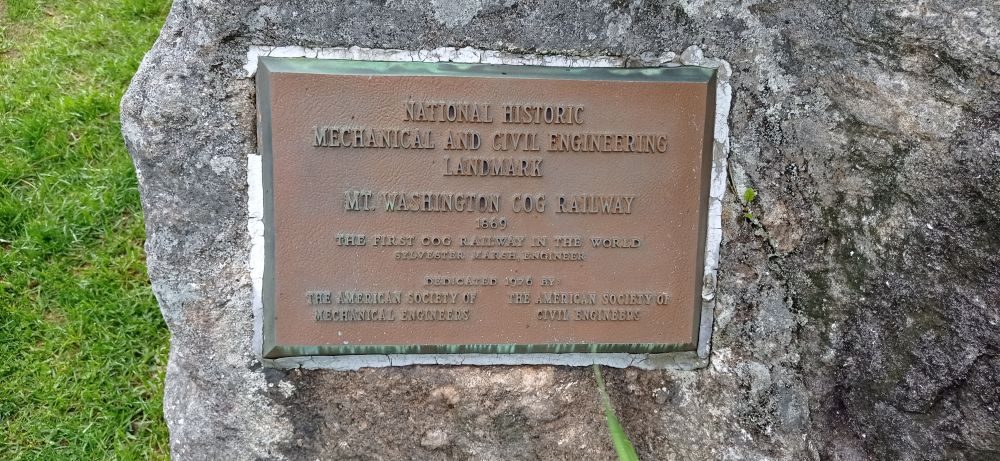
4代火車機車
鐵路已經建成了153年了
車站裏鐵路博物館的蒸汽機車內部
要走了,山下雨停了。
第二天是一個風和日麗的好天氣,我還感覺有個遺憾,一是應該爬上山去,二是一覽眾山小,遠眺波士頓。
老生常談12 發表評論於
回複 '北邙之巔' 的評論 :
LP說,開車的道路很險,有的就在懸崖邊上。
北邙之巔 發表評論於
還是別開車上,太刺激,還是火車安全,和軌道有齒輪齧合,看著就踏實。
delta2020 發表評論於
Mount Mitchell
Mount-mitchell-south-nc1.jpg
Mount Mitchell, viewed from Mount Craig
Highest point
Elevation 6,684 ft (2,037 m)[1]
Prominence 6,089 ft (1,856 m)[1]
Isolation 1,189 miles (1,914 km)
Listing
World most isolated peaks 31st
North America isolated peaks 4th
US most prominent peaks 62nd
U.S. state high points 16th
Ultra
Coordinates 35°45′53″N 82°15′54″WCoordinates: 35°45′53″N 82°15′54″W[2]
Geography
Mount Mitchell is located in North CarolinaMount MitchellMount Mitchell
North Carolina, U.S.
Show map of North Carolina
Show map of the United States
Show all
Location Yancey County, North Carolina, United States
Parent range Appalachian Mountains
Topo map USGS Mount Mitchell
Climbing
Easiest route Hike
Mount Mitchell, known in Cherokee as Attakulla,[3] is the highest peak of the Appalachian Mountains and the highest peak in mainland eastern North America. It is located near Burnsville in Yancey County, North Carolina; in the Black Mountain subrange of the Appalachians, about 19 miles (31 km) northeast of Asheville. It is protected by Mount Mitchell State Park and surrounded by the Pisgah National Forest. Mount Mitchell's elevation is 6,684 feet (2,037 m) above sea level.[1]
在New Hampshire的白山有一片總統山脈,由13個山峰組成,9座山海拔超過4000英尺,其中7座山峰命名為總統的名字:Mount Washington, Mount Adams, Mount,Jefferson,Mount Madison, Mount Monroe, Mount Franklin, Mount Eisenhower。
上個月Memorial Day長周末和LP到白山爬山。5月28日開車到達白山已經過了中午,決定到華盛頓山去。1784年Reverend Jeremy Belknap首先記錄了華盛頓山峰。華盛頓山海拔6228英尺(1917米),是密西西比河以東最高的山峰。以風大,氣候惡劣多變著名。不到山頂上很難想象狂風像脫韁的野馬,冰雨刺骨撕心裂肺之寒冷。
 乘坐這輛燒煤的蒸汽火車