過日子(北美旅遊篇)
輕吟淺酌過日子 合家歡樂夫妻子 平安健康一輩子


Niagara Fall
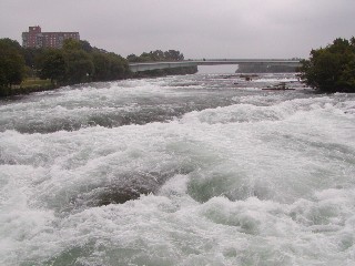
I am sure you had seen pictures of Niagara falls more than once; quite likely, you had also visited the falls in person - after all, the place is teeming with tourists. To get a decent shot there, most of the time you need a good stick more than a good camera (as often as not, a sturdy umbrella is also essential). Since barrel rides are currently illegal on the Canadian side (and are quite difficult to enjoy on the other side of the border due to the nasty boulders you'll have to land on after the 90-feet drop), the best way to get an unobscured view of the falls in summer time is probably to go for a helicopter ride. If you aim your camera very carefully, and just manage to avoid the hideous eyesore of the International Niagara Water Control Project, you might be lucky enough to take a nice picture or two.


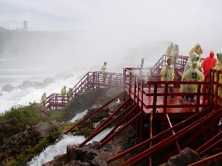
This was taken along a walkway overlooking the Horseshoe falls. Millions of gallons of water pour over these falls every hour. The mist stirred up by the fast flowing water is almost blinding. Quite a site to see.
IN FALL
Collectively they are called "Niagara Falls" |
|
Categorized by these three names: |

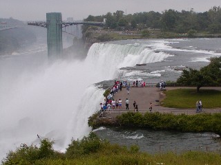
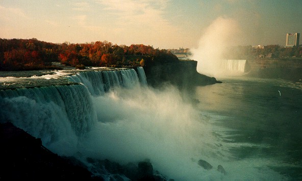
American Falls (between Prospect Point and Luna Island) far left
Bridal Veil Falls (between Luna Island and Goat Island) mid left
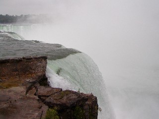
Canadian/Horseshoe Falls (between Goat Island and Table Rock) right
American Falls & Bridal Veil Falls |
 |
| photo credit: Al Melhinch |
length of brink: 1060 feet |
height: 176 feet (due to rocks at the base actual fall is 70 feet) |
volume of water: 150,000 U.S. Gallons per second |
| Actual amount varies, there are two hydroelectric plants which draw water into their |
| reservoirs prior to the Falls. Their intake greatly affects the volume of water flowing over |
| the falls. The amount of water being siphoned away depends on two variables. The time |
| of year, and the time of the day. Flow is greatest in the daytime during peak tourist |
| season (June, July, and August). In the event of an emergency the flow can be |
| somewhat reduced by the hydroelectric companies increasing their intake. |
| The Bridal Veil Falls is named for its appearance. It is located next to the American falls, |
separated by a small piece of land called Luna Island. |
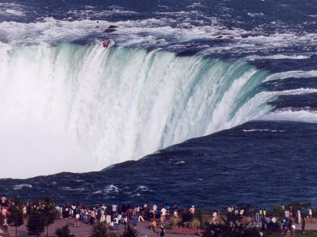
Canadian "Horseshoe" Falls |
length of brink: 2600 feet height: 167 feet volume of water: 600,000 U.S. gallons per second |

| Interesting fact: According to the U.S.G.S. (United States Geological Survey) of Niagara |
| Falls, it appears that almost 1/3 of the Canadian Falls lies within US Territory. |
|
| A Brief History of the Falls |
| Information below graciously provided courtesy of Niagara Parks Ice Age History of the Niagara River and Whirlpool Rapids The Niagara River, as is the entire Great Lakes Basin of which the river is an integral part, is a legacy of the last Ice Age. 18,000 years ago southern Ontario was covered by ice sheets 2-3 kilometers thick. As they advanced southward the ice sheets gouged out the basins of the Great Lakes. Then as they melted northward for the last time they released vast quantities of meltwater into these basins. Our water is "fossil water"; less than one percent of it is renewable on an annual basis, the rest leftover from the ice sheets. The Niagara Peninsula became free of the ice about 12,500 years ago. As the ice retreated northward, its meltwaters began to flow down through what became Lake Erie, the Niagara River and Lake Ontario, down to the St. Lawrence River, and, finally, down to the sea. There were originally 5 spillways from Lake Erie to Lake Ontario. Eventually these were reduced to one, the original Niagara Falls, at Queenston-Lewiston. From here the Falls began its steady erosion through the bedrock. However, about 10,500 years ago, through an interplay of geological effects including alternating retreats and re-advances of the ice, and rebounding of the land when released from the intense pressure of the ice (isostatic rebound), this process was interrupted. The glacial meltwaters were rerouted through northern Ontario, bypassing the southern route. For the next 5,000 years Lake Erie remained only half the size of today, the Niagara River was reduced to about 10% of its current flow, and a much-reduced Falls stalled in the area of the Niagara Glen. About 5,500 years ago the meltwaters were once again routed through southern Ontario, restoring the river and Falls to their full power. Then the Falls reached the Whirlpool. It was a brief and violent encounter, a geological moment lasting only weeks, maybe even only days. In this moment the Falls of the youthful Niagara River intersected an old riverbed, one that had been buried and sealed during the last Ice Age. The Falls turned into this buried gorge, tore out the glacial debris that filled it, and scoured the old river bottom clean. It was probably not a falls at all now but a huge, churning rapids. When it was all over it left behind a 90-degree turn in the river we know today as the Whirlpool, and North America's largest series of standing waves we know today as the Whirlpool Rapids. The Falls then re-established at about the area of the Whirlpool Rapids Bridge upriver to our right, and resumed carving its way through solid rock to its present location. |
Straddling the Canadian-United States International Border and both in the Province of Ontario |
and the State of New York, Niagara Falls attracts some 12 Million tourists to her majestic |
awesome beauty each year. |
| The Niagara is a fairly young river, only 12,000 years old!, a microsecond in geological time. The |
| Niagara Escarpment, which was created by erosion is much older. The glaciers pressed down on |
the land during the last ice age and laid down layers of sediment, then the slow process of erosion |
| of ice and water ate at the surface of the escarpment |
| . |
The mighty river plunges over a cliff of dolostone and shale. Niagara Falls is the second largest |
| falls on the globe next to Victoria Falls in southern Africa. |
One fifth of all the fresh water in the world lies in the four Upper Great Lakes-Michigan, Huron, |
| Superior and Erie. All the outflow empties into the Niagara river and eventually cascades over |
| the falls. |
At the bottom of the falls, the water travels 15 miles over many gorges until it reaches the fifth |
| Great Lake-Ontario. The land between the lakes does not slope at an even grade, but forms a |
| spectacular drop approximately the same height as a 20 story building and this is known as the |
| "Niagara Escarpment" Two billion years ago it was buried under a blanket of ice. |
| As the years past, the process of erosion took place, (and still does) five distinct 'gorges' were |
| formed-Lewiston Brange Gorge, Old Narrow Gorge, Upper & Lower Great Gorges and the |
| Whirlpool Narrow Gorge. |
Approximately 500 years ago the river encountered an obstacle that caused it to 'split into two |
| channels', thus Goat Island was formed named after John Stedman whose goat herds froze to |
| death in the winter of 1780). This was the original sediment left from a vanished Lake Tonawanda |
| (an Indian name). |
| On the eastern part of the island, the American Falls took shape, the Horseshoe Falls, is on the |
western side, where the river angles some 90 degrees. |
The water flow on the American side of the falls is much less in strength because of Goat Island, |
| whereas Horseshoe Falls has no obstruction to divert it. |
| It should be noted that a third much narrower falls exists. Over the years these falls have been |
called at different times; Luna Falls, Iris Falls and is currently named Bridal Veil Falls. |
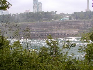
| Man has not been able to completely control the flow of the water over the falls, even modern |
| engineers have tried. Much of the water today is fed through underground channels and pipes to |
| nearby hydro electric power stations. |

Do the Falls Freeze over in the Winter? |
|

Yes and No...... We'll try to explain
| The tremendous volume of water never stops flowing, However, the falling |
| water and mist create ice formations along the banks of the falls and river. |
| This can result in mounds of ice as thick as fifty feet. If the Winter is cold for |
| long enough, the ice will completely stretch across the river and form what |
| is known as the "ice bridge". This ice bridge can extend for several miles |
| down river until it reaches the area known as the lower rapids. |
| Until 1912,visitors were allowed to actually walk out on the ice bridge and |
view the Falls from below. February 24th of 1888 the local newspaper |
| reported that at least 20,000 people watched or tobogganed on the ice. |
| Shanties selling liquor, photographs and curiosities abounded. On February |
| 4th 1912 the ice bridge broke up and three tourists lives were lost. |
There can also be a great deal of "mini-icebergs" which flow down the |
| Niagara River from frozen Lake Erie. The flow of ice has been reduced |
| considerably by the yearly installation of the "ice-boom" on Lake Erie. The |
| ice-boom is a long floating chain (2miles- 3.2 KM) of steel floats strung across |
| the Niagara River from Buffalo New York to Fort Erie Ontario. |
| It is set in place during the month of December and removed during the |
| month of March or April. It is maintained by the New York State Power |
| Authority. The ice boom helps prevent the ice from clogging the river and most |
| importantly the hydroelectric companies water intakes. |
|
Spring Ice flowing underneath the North Grand Island Bridge |
| HOWEVER.... The flow of water was stopped completely over both falls |
| on March 29th 1848 due to an ice jam in the upper river for several hours. This |
| is the only known time to have occurred. The Falls did not actually freeze |
| over, but the flow was stopped to the point where people actually walked out |
| and recovered artifacts from the riverbed! |

The "Ice Bridge" underneath the Rainbow Bridge. 1997 |
 |
Interesting facts about Niagara Falls |
| The flow over the American Falls was stopped completely for several months |
| in 1969. The idea was to determine the feasibility of removing the large |
| amount of loose rock from the base of the falls to enhance it's appearance. |
| In the end the final decision was that the expense would be too great. |
|

| photo credit: Lindsay News & Photo |
| The word "Niagara" is derived from the Iroquois Indian word "Onguiaahra" |
| meaning "the strait" |
| There is an international boundary between the United States and Canada. |
| Before the invention of film, tourists would sketch pictures of the Falls. |
| The flow was also halted over both falls on March 30th 1848 due to an ice jam |
| in the upper river. |
The movies Niagara and Superman were filmed in part at the Falls. |
In the past ten years, two daredevils lost their lives trying to conquer Niagara. |
| In the evenings, intense spotlights bathe the falls with different shades of color. |

| The first person to go over the Falls in a barrel and survive was a 63 year old | |
| female schoolteacher. | |
| High wire tightrope acts used to be performed across the river. Most notably | |
| was "Blondin" who once actually carried his manager across on his back, | |
| stopping midway to rest ! | |
| The Falls make a tremendous sound as the water goes over and lands at the | |
| bottom. | |
| Twenty percent of the worlds freshwater lies in the Great Lakes, and most flows | |
over Niagara Falls.
A notable part of the international boundary between the United States and Canada. NIAGARA RIVER FLOWS FIFTEEN MILES FROM LAKE ERIE INTO LAKE ONTARIO The word "Niagara" is derived from the Iroquois Indian word
|