amastroller
喜歡閑逛閑攝而已,無其它不良嗜好
正文
ZT:
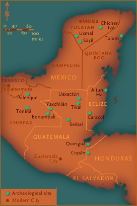
In its heyday from about A.D. 300 to 900, the Maya civilization boasted hundreds of cities across a vast swath of Central America. Now archeological sites, these once-flourishing cities extended from Chichén Itzá in the northern Yucatán to Copán, about 400 miles to the south in modern-day Honduras. Each bore ceremonial centers where theocratic rulers practiced a complex religion based on a host of gods, a unique calendar, and ceremonies that featured a ball game and human sacrifice. The ancient Maya also mastered astronomy, mathematics, art and architecture, and a glyph system of writing on stone, ceramics, and bark paper. Using an interactive map, visit 15 of the better-known Maya sites.—Peter Tyson
Chichén Itzá
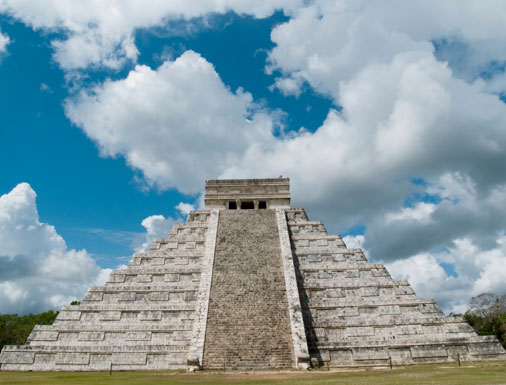
Chichén Itzá's 79-foot-tall Pyramid of Kukulkun
Chichén Itzá, "the mouth of the well of the Itzás," was likely the most important city in the Yucatán from the 10th to the 12th centuries. Evidence indicates that the site was first settled as early as the fifth century A.D. but was apparently abandoned thereafter. Then, in 964, the Itzás, a Maya-speaking people from the Petén rain forest around Tikal, moved into the city. Archeologists have fully explored only about 20 or 30 of several hundred buildings on the four-square-mile site. El Castillo (The Castle), a 98-foot-tall pyramid, dominates the city, while the Temple of the Warriors features murals of battle scenes and village life.
Tulum
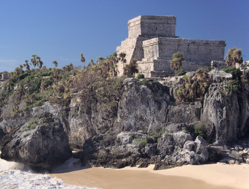
Tulum's El Castillo towers over the Caribbean coast.
Tulum was the largest Maya coastal city and the only Maya city known to have been inhabited when the Spanish arrived. Its buildings exhibit classic Maya architecture. The Temple of the Frescoes, for instance, which retains faint traces of blue-green frescoes, has a vaulted roof and triangular architecture. Other structures of note include the Castillo, the largest and most renowned building, which stands at the edge of a 40-foot cliff; and the Temple of the Descending God, named for a carving over the doorway of a winged god plunging toward Earth.
Palenque
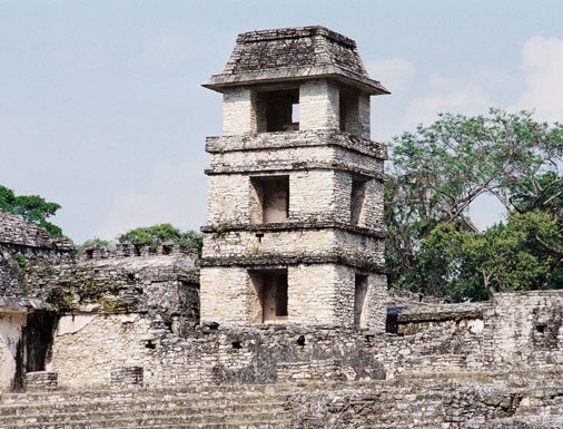
The ruins of Palenque rise above the surrounding Chiapas plain.
Distinguished by its highly expressive relief sculpture, Palenque comprises temples, terraces, plazas, altars, burial grounds, and a ball court. It was discovered accidentally in 1740, when a Spanish priest named Antonio de Solis struck a buried wall with his spade while planting a field. In its heyday, the city encompassed an area of almost 50 square miles. The most important buildings date to the sixth to ninth centuries, including the 75-foot-tall Temple of the Inscriptions. The temple was dedicated to the great ruler Pakal, who has been called the "Mesoamerican Charlemagne." His tomb, found by Mexican archeologists in 1952, lies at the bottom of a set of steps leading 80 feet down from the top of the temple.
Uxmal
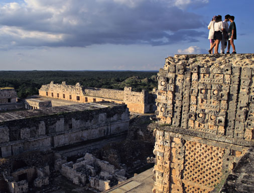
Tourists atop an intricately carved temple at Uxmal
Contemporary with Palenque and Tikal, Uxmal is an architectural gem whose buildings reflect a renaissance of Maya building that took place in the seventh to nine centuries A.D. The architectural style epitomized here is known as Puuc, which means "low hill" in Maya. Puuc blends ornate stone mosaics and cornices with vaulted arches and rows of columns. The archeologist Victor von Hagen called one of Uxmal's buildings, the House of the Governor, the most magnificent edifice ever erected in the Americas. Covering five acres, the palace features a façade frieze consisting of no fewer than 20,000 individually cut stones.
Bonampak

A well-preserved fresco scene decorates a tomb at Bonampak.
The explorer Jacques Soustelle called Bonampak "a pictorial encyclopedia of a Mayan city." Built along the Lacanjá River in the seventh and eighth centuries and eventually abandoned to the jungle, the city remained undiscovered until 1946. Even now it remains more difficult to get to than most other Maya sites (save for Yaxchilán, which still requires a one-hour jungle boat ride to reach). Bonampak means "painted walls" in Maya, and the site is known for just that: beautiful murals depicting the life of the ancient Maya. The three-roomed Templo de las Pinturas has remarkably well-preserved murals still bearing ochre and faience colors.
Yaxchilán
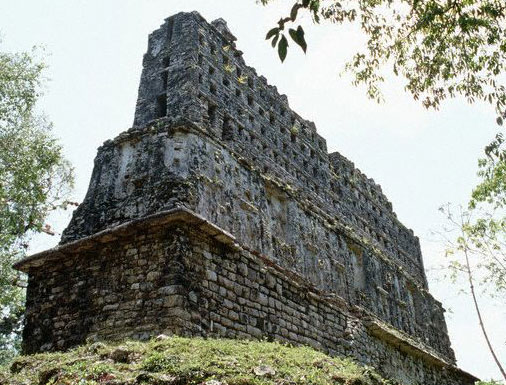
The pierced roof comb of Temple 33 is characteristic of Yaxchilán's striking architecture.
Perched on the western bank of the Usumacinta River, Yaxchilán ("the place of green stones") lay along the trade route between the two great Maya sites of Palenque and Tikal. But today it stands in a remote, little-visited jungle setting. Known for its handsome temples and exceptional carvings, this white-stoned city reached its peak during the Late Classic Period, from about 680 to 770. Two acropolises with temples, grand staircases, and a palace dominate the site. Legend has it that a headless sculpture of the god Yaxachtun at the site formerly terrified the local Lacandon people, who feared that the world would end when the head was replaced.
Tikal
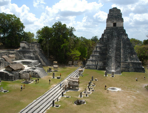
Temple I overlooks Tikal's Grand Plaza.
With its plethora of palaces, altars, shrines, and soaring temples, Tikal may be the premier Maya site. For over 1,100 years, the Maya built here, expanding the site until it covered an area of 25 square miles. In its prime, the city may have had 100,000 residents, and it was ruled by a single dynasty of over 39 successive rulers. The heart of the site is the Grand Plaza, which is surrounded by the Central Acropolis, the North Acropolis, and Temples I and II. In the North Acropolis alone, 100 buildings lie piled atop one another. Temple I is 145 feet tall, but it is dwarfed by Temple IV. At 212 feet, Temple IV, built around 741, is the tallest pre-Columbian structure in the Western Hemisphere.
Quiriguá
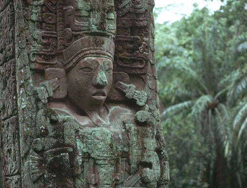
Stela carved from reddish sandstone, Quiriguá
Quiriguá is known for its many finely sculptured stone monuments. The site boasts the largest carved Maya stela, a 65-ton behemoth known as Monument 5. Dating to 771, Monument 5 stands 35 feet tall, with fully eight feet underground. Its sculptors worked in the local sandstone, which has a close and even grain that allows for highly intricate carvings. Beginning in 725, Quiriguá came under the power ofCopan; in that year, Copan ruler 18 Rabbit named Cauac Sky as ruler of Quiriguá. But 13 years later, Cauac Sky defeated 18 Rabbit in battle and sacrificed him, bringing Quiriguá independence and a rise to prominence that lasted until at least 810, the city's last recorded date.
Caracol
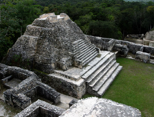
The ruins of Caracol in the jungle of southwestern Belize
Located in what is today southwestern Belize, Caracol, Spanish for "snail," rivaled anything in Belize today. At its peak between 650 and 700, the city had a population estimated at 150,000. (Belize's entire population is only about twice this today.) Caracol's largest structure, the 138-foot Caana ("Sky Place"), is the tallest building in either ancient or modern Belize. All told, in its prime, the site covered almost 15 square miles, had more than 36,000 occupied buildings, and included over 22 miles of sacheoh, or "white roads," made of blocks topped with crushed stone and plastered. A tomb found beneath a bench in the front room of Structure A3, a temple rising 52 feet above the Main Plaza, contained a single skeleton with 18 pounds of obsidian and 88 pounds of chert.
Altun Ha
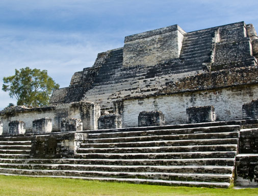
Altun Ha's magnificent Temple of the Sun God
Found on the outskirts of the Maya area, Altun Ha, which means "rockstone pond" in Yucatec Maya, is known for the fabulous jade that has turned up there. Dating to 550-600, the Temple of the Green Tomb earned its name after archeologists discovered nearly 300 jade objects sequestered within it. (The temple also contained a smashed codex or Maya book, whose paper had disintegrated but whose painted stucco surface remained in fragments.) The finest jade piece turned up in the Temple of the Masonry Altars, at over 58 feet the tallest structure at the site. In 1968, while archeologists excavated a tomb within the temple, they found a large, full-rounded sculpted head of Kinich Ahau, the sun god. Weighing almost ten pounds, it was the largest Maya carved jade object found until that time.
Sayil
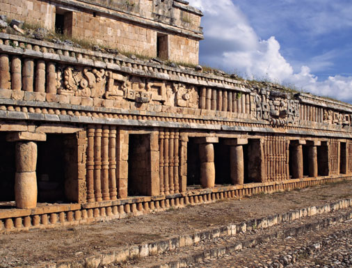
Sayil features elegant Puuc-style architecture.
A classic example of Puuc architecture (see also theUxmal entry), Sayil was established in the eighth century. Before that time, few Maya apparently lived in the region, probably because they had no efficient way to access the water table, which lies at least 200 feet belowground there. Only when local Maya learned to store water by digging chultunes, or small underground cisterns, were they able to expand their numbers significantly in the region. Each Sayil household had at least one chultune—a fact that has helped archeologists determine that by the ninth century, Sayil boasted about 17,000 urban and suburban residents. The site today features a platform for stelae, a ball court, and a number of palaces, including the magnificent Three-Storey Palace with its rounded columns.
Uaxactún
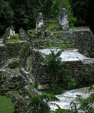
Uaxactún lies just 16 miles from Tikal, its rival city in ancient Maya times.
Uaxactún, which means "eight-stone" in Yucatec Maya and is named for the earliest stela found there (dated to A.D. 328), is one of the most intensively studied Maya sites. The ceramic sequence that came out of early work there provided the basis for the entire Maya lowland chronology. One of the most notable series of buildings at the site is that formed by Structures E-1, E-2, and E-3, which are aligned north-south and form an astronomical observatory, the first found in the Maya world. From an observation point on a nearby pyramid, the early Maya could watch the sun rise behind these buildings and mark the summer and winter solstices (the longest and shortest days of the year) as well as the vernal and autumnal equinoxes (when day and night are of equal length).
Seibal
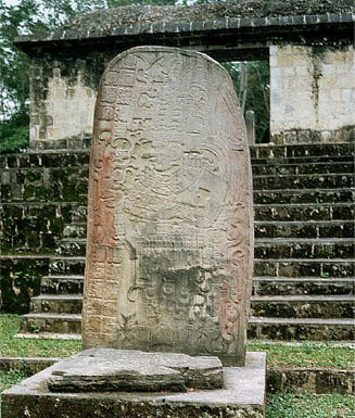
Stela 10 at Seibal portrays an elaborately clothed lord.
Spanish for "place of the ceiba tree," Seibal had a checkered history. First inhabited in the Middle Preclassic Period around 800 B.C., the city grew until about the time of Christ, when it began a long decline. It was apparently abandoned between roughly A.D. 500 and 690, when it was reoccupied. In 735, Ruler 3 from the Maya city known today as Dos Pilas, which lies southwest of Tikal, captured the ruler of Seibal, Yich'ak Balam, and his city, leading to about 60 years of foreign rule. Around 830, a non-Classic Maya group settled in Seibal, which witnessed its greatest florescence over the next century, its population reaching about 10,000. The city was permanently abandoned in 930 and not rediscovered until about 1890. Today, it is noted for its beautiful carved stelae sculpted from high-quality limestone.
Copán
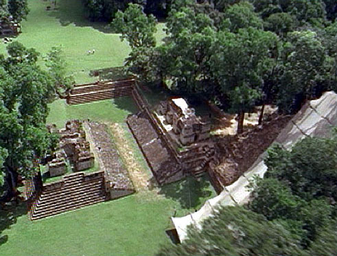
Ball court A-III (center) and the Hieroglyphic Stairway (under awning) at Copán
The first description of Copán appeared in a letter to Philip II, King of Spain, dated March 8, 1576. Since then, innumerable archeologists, tourists, and other visitors have descended on this spectacular Mayan city in northern Honduras. Among a plethora of renowned buildings, stelae, and other artifacts, arguably the most famous is the Hieroglyphic Stairway. The longest text in Precolumbian America, the stairway provides a history of Copán written in stone. Each of 2,200 blocks that form the risers of more than 70 steps bears carved glyphs that record the history of the 16-ruler Copán dynasty formed by Yax K'uk Mo'. The site's stelae, carved in greenish andesite in strikingly high relief, are equally fascinating. One of the most renowned, Altar Q, shows Yax K'uk Mo' passing the baton of office to Yax Pac, the 16th and final great ruler of Copán.
Toniná
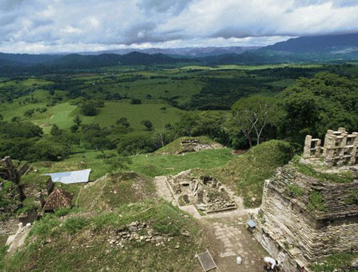
A lightly inhabited valley spreads out below the ruins of Toniná.
The wave of mysterious abandonment that swept through Classic Maya cities ends at this remote city in Chiapas, Mexico. The wave seems to have begun along the Usumacinta River, which today forms northwest Guatemala's border with Mexico. The last recorded date at Bonampak is 792, at Piedras Negras 795, at Palenque 799, and at Yaxchilán 808. The wave then moved east into the heart of Maya civilization in the Petén region of what is today modern Guatemala and south into Honduras. Quiriguáfell silent in 810, Copán in 822, Caracol in 859, andTikal in 889. The very last Classic Maya date—909—appears at Toniná. Strangely, no record of impending doom appears anywhere in Maya iconography. Scholars have advanced many possible causes of the collapse—among them plague, famine, earthquake, invasion, and peasant revolt—but the enigma remains.
*************************

In its heyday from about A.D. 300 to 900, the Maya civilization boasted hundreds of cities across a vast swath of Central America. Now archeological sites, these once-flourishing cities extended from Chichén Itzá in the northern Yucatán to Copán, about 400 miles to the south in modern-day Honduras. Each bore ceremonial centers where theocratic rulers practiced a complex religion based on a host of gods, a unique calendar, and ceremonies that featured a ball game and human sacrifice. The ancient Maya also mastered astronomy, mathematics, art and architecture, and a glyph system of writing on stone, ceramics, and bark paper. Using an interactive map, visit 15 of the better-known Maya sites.—Peter Tyson
Chichén Itzá

Chichén Itzá's 79-foot-tall Pyramid of Kukulkun
Chichén Itzá, "the mouth of the well of the Itzás," was likely the most important city in the Yucatán from the 10th to the 12th centuries. Evidence indicates that the site was first settled as early as the fifth century A.D. but was apparently abandoned thereafter. Then, in 964, the Itzás, a Maya-speaking people from the Petén rain forest around Tikal, moved into the city. Archeologists have fully explored only about 20 or 30 of several hundred buildings on the four-square-mile site. El Castillo (The Castle), a 98-foot-tall pyramid, dominates the city, while the Temple of the Warriors features murals of battle scenes and village life.
Tulum

Tulum's El Castillo towers over the Caribbean coast.
Tulum was the largest Maya coastal city and the only Maya city known to have been inhabited when the Spanish arrived. Its buildings exhibit classic Maya architecture. The Temple of the Frescoes, for instance, which retains faint traces of blue-green frescoes, has a vaulted roof and triangular architecture. Other structures of note include the Castillo, the largest and most renowned building, which stands at the edge of a 40-foot cliff; and the Temple of the Descending God, named for a carving over the doorway of a winged god plunging toward Earth.
Palenque

The ruins of Palenque rise above the surrounding Chiapas plain.
Distinguished by its highly expressive relief sculpture, Palenque comprises temples, terraces, plazas, altars, burial grounds, and a ball court. It was discovered accidentally in 1740, when a Spanish priest named Antonio de Solis struck a buried wall with his spade while planting a field. In its heyday, the city encompassed an area of almost 50 square miles. The most important buildings date to the sixth to ninth centuries, including the 75-foot-tall Temple of the Inscriptions. The temple was dedicated to the great ruler Pakal, who has been called the "Mesoamerican Charlemagne." His tomb, found by Mexican archeologists in 1952, lies at the bottom of a set of steps leading 80 feet down from the top of the temple.
Uxmal

Tourists atop an intricately carved temple at Uxmal
Contemporary with Palenque and Tikal, Uxmal is an architectural gem whose buildings reflect a renaissance of Maya building that took place in the seventh to nine centuries A.D. The architectural style epitomized here is known as Puuc, which means "low hill" in Maya. Puuc blends ornate stone mosaics and cornices with vaulted arches and rows of columns. The archeologist Victor von Hagen called one of Uxmal's buildings, the House of the Governor, the most magnificent edifice ever erected in the Americas. Covering five acres, the palace features a façade frieze consisting of no fewer than 20,000 individually cut stones.
Bonampak

A well-preserved fresco scene decorates a tomb at Bonampak.
The explorer Jacques Soustelle called Bonampak "a pictorial encyclopedia of a Mayan city." Built along the Lacanjá River in the seventh and eighth centuries and eventually abandoned to the jungle, the city remained undiscovered until 1946. Even now it remains more difficult to get to than most other Maya sites (save for Yaxchilán, which still requires a one-hour jungle boat ride to reach). Bonampak means "painted walls" in Maya, and the site is known for just that: beautiful murals depicting the life of the ancient Maya. The three-roomed Templo de las Pinturas has remarkably well-preserved murals still bearing ochre and faience colors.
Yaxchilán

The pierced roof comb of Temple 33 is characteristic of Yaxchilán's striking architecture.
Perched on the western bank of the Usumacinta River, Yaxchilán ("the place of green stones") lay along the trade route between the two great Maya sites of Palenque and Tikal. But today it stands in a remote, little-visited jungle setting. Known for its handsome temples and exceptional carvings, this white-stoned city reached its peak during the Late Classic Period, from about 680 to 770. Two acropolises with temples, grand staircases, and a palace dominate the site. Legend has it that a headless sculpture of the god Yaxachtun at the site formerly terrified the local Lacandon people, who feared that the world would end when the head was replaced.
Tikal

Temple I overlooks Tikal's Grand Plaza.
With its plethora of palaces, altars, shrines, and soaring temples, Tikal may be the premier Maya site. For over 1,100 years, the Maya built here, expanding the site until it covered an area of 25 square miles. In its prime, the city may have had 100,000 residents, and it was ruled by a single dynasty of over 39 successive rulers. The heart of the site is the Grand Plaza, which is surrounded by the Central Acropolis, the North Acropolis, and Temples I and II. In the North Acropolis alone, 100 buildings lie piled atop one another. Temple I is 145 feet tall, but it is dwarfed by Temple IV. At 212 feet, Temple IV, built around 741, is the tallest pre-Columbian structure in the Western Hemisphere.
Quiriguá

Stela carved from reddish sandstone, Quiriguá
Quiriguá is known for its many finely sculptured stone monuments. The site boasts the largest carved Maya stela, a 65-ton behemoth known as Monument 5. Dating to 771, Monument 5 stands 35 feet tall, with fully eight feet underground. Its sculptors worked in the local sandstone, which has a close and even grain that allows for highly intricate carvings. Beginning in 725, Quiriguá came under the power ofCopan; in that year, Copan ruler 18 Rabbit named Cauac Sky as ruler of Quiriguá. But 13 years later, Cauac Sky defeated 18 Rabbit in battle and sacrificed him, bringing Quiriguá independence and a rise to prominence that lasted until at least 810, the city's last recorded date.
Caracol

The ruins of Caracol in the jungle of southwestern Belize
Located in what is today southwestern Belize, Caracol, Spanish for "snail," rivaled anything in Belize today. At its peak between 650 and 700, the city had a population estimated at 150,000. (Belize's entire population is only about twice this today.) Caracol's largest structure, the 138-foot Caana ("Sky Place"), is the tallest building in either ancient or modern Belize. All told, in its prime, the site covered almost 15 square miles, had more than 36,000 occupied buildings, and included over 22 miles of sacheoh, or "white roads," made of blocks topped with crushed stone and plastered. A tomb found beneath a bench in the front room of Structure A3, a temple rising 52 feet above the Main Plaza, contained a single skeleton with 18 pounds of obsidian and 88 pounds of chert.
Altun Ha

Altun Ha's magnificent Temple of the Sun God
Found on the outskirts of the Maya area, Altun Ha, which means "rockstone pond" in Yucatec Maya, is known for the fabulous jade that has turned up there. Dating to 550-600, the Temple of the Green Tomb earned its name after archeologists discovered nearly 300 jade objects sequestered within it. (The temple also contained a smashed codex or Maya book, whose paper had disintegrated but whose painted stucco surface remained in fragments.) The finest jade piece turned up in the Temple of the Masonry Altars, at over 58 feet the tallest structure at the site. In 1968, while archeologists excavated a tomb within the temple, they found a large, full-rounded sculpted head of Kinich Ahau, the sun god. Weighing almost ten pounds, it was the largest Maya carved jade object found until that time.
Sayil

Sayil features elegant Puuc-style architecture.
A classic example of Puuc architecture (see also theUxmal entry), Sayil was established in the eighth century. Before that time, few Maya apparently lived in the region, probably because they had no efficient way to access the water table, which lies at least 200 feet belowground there. Only when local Maya learned to store water by digging chultunes, or small underground cisterns, were they able to expand their numbers significantly in the region. Each Sayil household had at least one chultune—a fact that has helped archeologists determine that by the ninth century, Sayil boasted about 17,000 urban and suburban residents. The site today features a platform for stelae, a ball court, and a number of palaces, including the magnificent Three-Storey Palace with its rounded columns.
Uaxactún

Uaxactún lies just 16 miles from Tikal, its rival city in ancient Maya times.
Uaxactún, which means "eight-stone" in Yucatec Maya and is named for the earliest stela found there (dated to A.D. 328), is one of the most intensively studied Maya sites. The ceramic sequence that came out of early work there provided the basis for the entire Maya lowland chronology. One of the most notable series of buildings at the site is that formed by Structures E-1, E-2, and E-3, which are aligned north-south and form an astronomical observatory, the first found in the Maya world. From an observation point on a nearby pyramid, the early Maya could watch the sun rise behind these buildings and mark the summer and winter solstices (the longest and shortest days of the year) as well as the vernal and autumnal equinoxes (when day and night are of equal length).
Seibal

Stela 10 at Seibal portrays an elaborately clothed lord.
Spanish for "place of the ceiba tree," Seibal had a checkered history. First inhabited in the Middle Preclassic Period around 800 B.C., the city grew until about the time of Christ, when it began a long decline. It was apparently abandoned between roughly A.D. 500 and 690, when it was reoccupied. In 735, Ruler 3 from the Maya city known today as Dos Pilas, which lies southwest of Tikal, captured the ruler of Seibal, Yich'ak Balam, and his city, leading to about 60 years of foreign rule. Around 830, a non-Classic Maya group settled in Seibal, which witnessed its greatest florescence over the next century, its population reaching about 10,000. The city was permanently abandoned in 930 and not rediscovered until about 1890. Today, it is noted for its beautiful carved stelae sculpted from high-quality limestone.
Copán

Ball court A-III (center) and the Hieroglyphic Stairway (under awning) at Copán
The first description of Copán appeared in a letter to Philip II, King of Spain, dated March 8, 1576. Since then, innumerable archeologists, tourists, and other visitors have descended on this spectacular Mayan city in northern Honduras. Among a plethora of renowned buildings, stelae, and other artifacts, arguably the most famous is the Hieroglyphic Stairway. The longest text in Precolumbian America, the stairway provides a history of Copán written in stone. Each of 2,200 blocks that form the risers of more than 70 steps bears carved glyphs that record the history of the 16-ruler Copán dynasty formed by Yax K'uk Mo'. The site's stelae, carved in greenish andesite in strikingly high relief, are equally fascinating. One of the most renowned, Altar Q, shows Yax K'uk Mo' passing the baton of office to Yax Pac, the 16th and final great ruler of Copán.
Toniná

A lightly inhabited valley spreads out below the ruins of Toniná.
The wave of mysterious abandonment that swept through Classic Maya cities ends at this remote city in Chiapas, Mexico. The wave seems to have begun along the Usumacinta River, which today forms northwest Guatemala's border with Mexico. The last recorded date at Bonampak is 792, at Piedras Negras 795, at Palenque 799, and at Yaxchilán 808. The wave then moved east into the heart of Maya civilization in the Petén region of what is today modern Guatemala and south into Honduras. Quiriguáfell silent in 810, Copán in 822, Caracol in 859, andTikal in 889. The very last Classic Maya date—909—appears at Toniná. Strangely, no record of impending doom appears anywhere in Maya iconography. Scholars have advanced many possible causes of the collapse—among them plague, famine, earthquake, invasion, and peasant revolt—but the enigma remains.
*************************
評論
目前還沒有任何評論
登錄後才可評論.


